
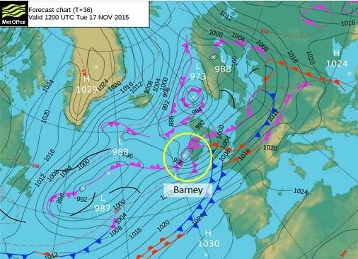
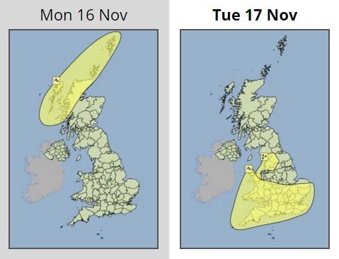
A YELLOW weather warning for Wiltshire and Swindon has been issued by the Met Office as Storm Barney is predicted to sweep eastward tomorrow.
The Met Office says west to southwesterly gales and locally severe gales are likely to sweep eastwards across parts of Wales, southern, central and eastern England later tomorrow as Storm Barney arrives.
Gusts could reach 60-70mph inland and possibly 80mph along exposed coasts, particularly Wales and through the Bristol Channel.
Travel could be disrupted, trees brought down and damage caused to 'weakened structures'.
Andy Page, Met Office chief meteorologist, said: "Storm Barney is expected to be a fast moving storm system bringing a few hours of severe gales to southern parts of Britain later tomorrow afternoon and evening.
"It brings the potential for travel disruption and could bring down trees.
"There remains a good deal of uncertainty in this evolution and particularly the location of the strongest winds in association with wind Storm Barney, so this warning will be kept under review and updated as necessary."
Following further spells of wet and windy weather in the second half of the week Met Office forecasters are expecting to see a change in the weather for the weekend as colder air moves across the UK from the north.
This will make it feel colder compared to recently, with temperatures close to or a little below average and will bring some wintry showers to higher ground in the north.
Local authorities affected include: Gloucestershire, South Gloucestershire, Swindon, Wiltshire, Bath and North East Somerset, Bristol, Dorset, North Somerset, Somerset, Devon, Cornwall, Bournemouth and the Isles of Scilly.
- The weather warning is now valid from 4pm on Tuesday until 11.30pm.


Comments: Our rules
We want our comments to be a lively and valuable part of our community - a place where readers can debate and engage with the most important local issues. The ability to comment on our stories is a privilege, not a right, however, and that privilege may be withdrawn if it is abused or misused.
Please report any comments that break our rules.
Read the rules here